Honeymoon Trek
- May 27, 2019
- 14 min read
It's hard to believe that it's been a month since our Nepal Himalayas trek ended. Sometimes it's better to look back and tell a story than it is to recount it while you are in the moment with all the emotions and opinions about it running around in your head. Three weeks of trekking in the Everest region was definitely a challenge, and an experience of a lifetime!

Our adventure started in Kathmandu, the capital and largest city in Nepal. The pleasant, sunny weather and mountain air instilled a sense of calm in us, but we only had 12 hectic hours to run errands- find an ATM that worked, drop off our laundry, buy SIM cards and cell plans, go to the pharmacy, stock up on toilet paper and snacks, reorganize all our bags, get to our pre-departure meetings (9am and 5pm), and try to finally post the darn China blog! While the narrow, windy streets of Thamel, Kathmandu's tourist haunt, would normally be a good place to slowly wander and peruse the little shops selling Nepali handicrafts, Buddhist souvenirs, woolen goods of all sorts, and of course, hippie clothes (Thamel is full of some serious hippies), we would have to save our souvenir shopping for our return.

At 7am the next morning, we took a jeep with our guide and gear towards Shivalaya, a small mountain village about 8 hours westward. After crawling slowly out of the congested Kathmandu valley, where honking is a necessity to stay alive, we stopped to pick up some fruit for the trek. Enough for all 20 days, because it's cheaper near the city than high up in the mountains (as was nearly everything). Nevermind that means the porter would have to carry another 20 pounds on his back, only getting slightly lighter each day after our evening dessert of apple, pomegranate and banana.


Nepal's past, present, and future are hugely influenced by geography, like few other places we've seen. Sandwiched between China and India, both massive, crowded, and culturally dominant places means Nepalis are pulled in multiple directions. While the people are pulled, the land is pushed. Up, way up. The physical scale of things was immense, the height of the mountains, the depth of the valleys, the size of the trees, the force of the rivers. These all make getting things and people places much more difficult, slow, and complicated.


Compared with China, the speed of development in Nepal is glacial. Putting a new road in through the deep river gorges and rocky cliffs is much easier said than done. This has kept many mountain villages more isolated from access to the expected parts of modern life. No road means no cars or trucks, which means far fewer goods available. In popular trekking regions where people outside of the tourism industry don't actually live year round, helicopters transport a substantial portion of the goods. I haven't got the math down yet on how many fully-loaded donkeys or yaks it takes to equal one semi. Not to mention all the porters (mostly young men) also transporting goods up into the hills.
Only the necessities (and a few bonus items if its on a busy trekking route) make it to these places; LP tanks, clothing, feed for animals, and some basic food staples like corn, wheat, rice, lentils and tea. If you want to eat something besides dhal bhat (rice and lentil soup) you need to produce it yourself. The common crops we saw were potatoes, garlic, eggs, yak cheese and at lower elevations, grains that could be fermented into "local wine".


If you want fire to cook or heat, you need to cut the firewood and haul it back to the village. If you live above tree-line, then dried yak dung is used for fuel. If you want to hear the story continued, then I have to backtrack.
We were told that the last couple hours of the 7 hour jeep ride to the beginning of the trek would be "bumpy". It was. There were few moments we accelerated into the double digits. Enormous ruts, enormous boulders, and shallow but steadily rushing rivers of recent snowmelt all contributed to throw us around in an on-road experience that might as well have been off-road. Our tailbones legitimately hurt when we arrived. A fun additional piece was that the driver had only done this trip once before and had to ask every person we passed if we were still headed in the right direction. Most people's answers looked something like a "keep going straight down this, the only, road" sort of gesture.
Finally, we made it in to the Shivalaya valley, famous as the original access route that Sir Edmund Hillary, Tenzing Norgay, and the rest of their team used on their way to the first successful summit of Mt. Everest (May 29, 1953). Now, almost 66 years later, most trekkers take a small jet from Kathmandu to a harrowing landing at the tiny airstrip in Lukla and skip 5 or 6 days of walking. We wanted to acclimatize more slowly, and avoid dying (there were at least two plane crashes just in April and apparently that is normal), so we walked through the valley, and were very glad that we did.

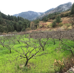
Shivalaya valley is mostly in the 7,000-10,000 ft. range giving us a good warm up for legs, heart, and lungs. We also got to see spring show up in the mountains. Large areas of blooming Rhododendrons and Daphnes were visible throughout this part of the hike, as well as the first crop of potatoes, spring garlic, wheat and the melting of the snow up above. We didn't know it at the time, but this was also the least crowded section of our trek. Once you reach the airport in Lukla the 'Everest Highway' begins. Along the highway we passed hundreds of people each day and stayed at teahouses that were full and required reservations. However, in Shivalaya we were mostly alone on the trail with the local Nepalis and their animals, and we shared the simpler teahouses with the whole family and only a few other foreign trekkers.


One of the cool parts of doing the warm-up hike in Shivalaya was seeing people's daily lives as we walked past. We passed by dozens of Buddhist Chortens and tiny monasteries, some very old and some very new. If you live way up high in Nepal and aren't serving tourists, you're probably shepherding some animals and growing some vegetables. There's really not much else available for job options. Most of the villages are just a few houses of stacked stones pulled from the surrounding mountains, chiseled flat-ish, and then sometimes covered in stucko. There's almost never any mortar, just rocks that mostly inter-lock pretty well. This isn't a secure way to build your house, but given the access to materials, it is the cheapest and most practical. Until a natural disaster hits. We saw lots of places either under construction or newly built due to the major destruction from the 8.0 earthquake in 2015.


One night, our teahouse host invited us, the only two guests, to attend a festival happening at the Tibetan Buddhist monastery a short hike down the hill. We were eager to see what an actual Tibetan Buddhist community looks like in the modern day. It was Dumchi, the festival of the hungry ghosts. Buddhists rid themselves of negative karma through offering to the hungry ghosts, dancing, and chanting. The hungry ghosts are representations of parts of all of us that constantly crave for things to be different than they are.

There were at least 100 people there to celebrate. In the middle of the scene was an altar with candles and offerings. The event was held under a huge tent covering the entry way to the meditation hall. The festival began with costumed men playing with the crowd. It was like a mix of warm-up comics, military men, and rodeo clowns, or something. Eventually the lamas came out and sat in front of the altars. Every few minutes the action was interrupted by the musicians in the back. Drums, bells, noise-makers, and some alpine-horn like instruments filling the space with a crescendo of noise celebrating the release from our hungry ghost karma.


Then there was dancing. First, by costumed characters in bright colors with lots of jumping and spinning, colored cloth following them round and round. Later, more of the audience joined in the dancing. The whole experience was so captivating, interesting, and very different than most religious experience we've been exposed to at home. The clothing and decorations were straight out of 'Kundun' or '7 Years in Tibet', but the young people in the audience were also pulling smart phones out of their knock-off North Face jackets. It felt like a window into something ancient, though still vibrant in the present. By 11pm we were ready to head back to the teahouse, which was a 20-minute walk back in total darkness.


We hiked with our guide, Kumar, an enthusiastic, outdoorsy guy who loves the action of trekking and the nighttime camaraderie with other guides better than his off-season life as a farmer. Kumar is Sherpa, one of the many cultural groups in Nepal. Our porter Lal, is also Sherpa and works on a construction crew when there isn't porter work available. It was amazing how much Lal could carry and usually at our hiking pace. Not only that, but he did it in sandals that revealed his cracked heels with a smile on his face.


A Nepali law now officially limits trekking porters to carrying 25 kilos (55lbs.) in their load. However, we saw many other porters carrying what was easily 75-100lbs. of food and supplies. It was truly unbelievable! Most of the guides start out as porters and work their way into the guide position, which usually pays the same hourly rate, but guides get better tip and don't have to carry as much weight. From what our guide explained, both guide and porter receive $15-$20 per day, depending on experience, and also have their lodging and food covered during the trek. As for other porters, who do not work for a trekking company, they are paid based on how much weight they can carry per load and so they typically haul as much as humanly possible-rain or shine! Many of them are young, wearing ripped jeans and tennis shoes or flip flops, bumping their transportable radios with the latest pop music.


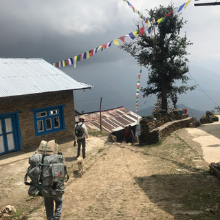
Being our first ever 'teahouse trek', there were lots of differences. Unlike backpacking in the U.S., lots of people both live and offer accommodations and food along the popular teahouse routes. There are some major advantages to this type of trip like; you don't have to set up a tent in the rain, carry a stove and food, or even much water, as there are taps available at every house with water running straight off the mountain. Filtering still recommended. There's also a toilet (usually squat), a shower (either bucket or occasionally hot water for purchase), and a bed and blankets. They also sell things like toilet paper, Snickers, Pringles, and thermoses of hot water for the in-the-know who brought along their own tea bags and sugar. The down-side, of course, can be that the number of other trekkers detracts from the solitude.


At the teahouses you order meals off a menu like at a normal restaurant. However, if there's more than a couple people there, it's wise to put your order in early (the night before for breakfasts), as the cooking space and the kitchen help are limited. At first the idea of hiking all day and rolling into a place where a warm meal will be on the table is great. A couple weeks in though, the menu offerings start to get quite repetitive. As we mentioned, getting food up there is difficult, so the menu is usually small, and vegetarian. However, the portions are often HUGE and we our tour included three meals a day! Momos and dal bhat were our favorites because Western foods were not their specialty.


Along the way almost all the houses double as teahouses, meal stops or little shops catering to trekkers. Conveniently for us, all the tourist marketing is in English, with German coming in a distant second. A few places advertised a "cheese shop", which we were pretty excited about. In the Nepal Himalaya, if you've got a wheel of cheese and you're willing to let people into your kitchen to buy some, you've got a cheese shop. The cheese, like most of the items available, wasn't a total bargain, we usually paid something around $6-$8 a pound, but it is artisan, small batch, organic, and an excellent addition to our nightly fruit plate.


Speaking of prices, we were regularly warned by our guide that we should enjoy our splurge items early on because once we reached Namche Bazaar (11,290ft.) and the 'Everest Highway' prices will go way up. This was very true. The teahouse room that previously cost $2-$4 was now 3x that amount. The food prices increased too, though not as much, hot showers doubled in price, bottled waters that were $0.75 went for $3 (but our filters saved us having to deal with this). This was an excellent reminder of what it really means to be a luxury item. Someone or some animal carried that case of bottled waters up to 15,000ft.


Things got even more expensive at Everest View Hotel, with fancy tea service and a helipad.


Almost everyone refers to Namche Bazaar as just 'Namche'. Hiking in the Everest area is all about Namche- how long until you get there, how long until you get back, are you on your way up or down from Namche? It's the largest village for miles around and offers the widest range of options for travelers. Anything you forgot to get back in Kathmandu can probably be picked up in Namche. There's espresso, burgers, bakeries, reliable WiFi, outdoor gear, souvenirs, boot cobblers, the world's highest Irish Pub, laundry services, and heli pads for those with enough money to skip even more walking.
The first time through, on the way up, Namche felt great. We had been trekking for over a week, and the hot shower in the basic ensuite bathroom, internet, and wider menu options all felt very luxurious. Soak it up now, we were told, because after Namche things get more difficult and the options fewer, but if you want the best views, you've got to keep going.


So we did, with Gokyo Lakes being our ultimate destination. We were shooting for a clear view from the lookout point at Gokyo Ri at 17,360ft., the highest either of us planned on ever hiking. On the first day of walking after Namche the trail splits, you can head east toward Everest Base Camp or North toward Gokyo. Everest Base Camp (EBC) is far and away the most popular trek in the country and sees more than 30,000 people per year. There's rumored to be some incredible views nearby, but base camp itself, our guide says, isn't much to write home about. Not to mention all the people. April is the spring season for Everest summit climbs, so base camp would be even more crowded. So we skipped it, and opted for Gokyo Lakes which see about only 20% the number of trekkers that go to EBC.
As you climb higher, the pack animals transition from majority donkeys and mules to majority yaks. There's also something called a Chogye that is a Yak/Cow crossbreed. They can't make it as high as the yaks, but higher than the donkeys, and they're bigger and can carry more weight. The cutest of all, Leah will tell you, are the baby yaks. We also saw some wild animals- mountain goats and lots of eagles and other cool raptors. The Nepal currency does a nice job of showing off the animal riches of the country with bills featuring rhinos, tigers, various mountain goats, snow leopards, and yaks. America has lots of cool wildlife too, but we just get to look at dead, white men on our currency.


We both enjoy hiking, biking, camping, traveling, and generally being outside. However, it has never seemed so clear how much of a dice roll it can be to do these activities that depend on good weather for success. Back in Shivalaya there were a few rainy days; the conversation kept being, "let's just hope it's clear when we get up there." What else can you do? We both ended up buying umbrellas after about five days in, which we used on both sunny days and rainy days. (Thanks to our guide for the tip!) The plan B for most trekking groups is to add in extra days, so a rainy one can be spent reading in the teahouse, and then followed by an attempt at the viewpoint again the next day. We had some extra time built in for this reason, if needed, when we reached our highest teahouse at Gokyo.


April, when we were there, is considered the 2nd best time of the year for clear views on a trek in most of Nepal. October/November is supposed to be the most reliably clear time of year, though our guide tells us you have to deal with colder temperatures. June to September is monsoon and that means lots of moisture and clouds, while winter is just too snowy and cold.
Just like everybody else, we had been checking the weather, asking our guides about the weather, and talking to others at the teahouse about how we hoped the weather would be good. Luckily, the forecast for the next day was looking clear until at least noon for our planned hike up to the Everest photo-op at Gokyo Ri. Snow was predicted later in the day and our planned climb over Renjo Pass to make a loop rather than doubling back to Namche was in doubt. At least we'd get the view though.
From the town of Gokyo, which is really all just teahouses, nobody lives there year-round as far as we can tell, it's 1,500 vertical feet up to the lookout at Gokyo Ri. Some people opt for the first light ascent around 6am as the mornings tend be clearer. We went for the more relaxed wake-up and breakfast, departing about 8 and banking on the forecast to hold out. The steep climb, although a relatively short distance, took nearly 2 hours because moving at that altitude is hard. Even after 2 weeks of walking everyday and slowly gaining in elevation. Our hearts beat faster and harder and we needed short breaks every 5 or 10 minutes as we tried to slow down our breathing.


It all worked out and we joined a few other groups enjoying the sunny views at the top. After half an hour or so of photos and gawking at the hugeness of the mountains and glaciers, some clouds started to roll in. As we descended, other groups going up were pushing to make it for the views before they disappeared. Or they'd have to wait another day and try again. If there wasn't time for another day, they'd have to go home without seeing the enticing views on the website and the brochure.


It did snow overnight and all the groups planning to attempt Renjo Pass that morning decided not to chance it. We went back the way we came, headed down toward Namche and the end of the trek. It turned into a sunny, snow-covered day.


The day before we were supposed to get back to Namche we were bound for a tiny village that was just two teahouses on top of a jagged little pass where the wind never seems to stop. On the way, it rained and hailed for almost 2 hours. It was the most non-stop hail we had ever seen. By that point in the trip we had our strategy ready with rain pants, coats, and umbrellas. Hiking underneath an umbrella when it's pouring is highly recommended.

At Namche we had time for a side hike up to a Tibetan Buddhist monastery. The monastery, or in this case nunnery, as it was all female monks, was a transplant to the area. The nuns escaped across the border from Chinese controlled Tibet in the 1950s and re-established their monastery in a new location in Nepal. We sat down inside and listened as the group chanted scripture recitations. We also found some of the best momos of the trip at a nearby teahouse for lunch that day, which made us happy.


After Namche, we headed down to Lukla for an early morning flight (it's usually clearer and thus safer then) out the next day. Lukla had the smallest airport with the least serious security check, the shortest runway, and the smallest jets we've ever seen. It was our first time literally walking to an airport, just over 5 minutes to get there! The 20-minute flight had some nice views as it headed down into the valley and brought our trek nearly to its end. First, we'd have to ride 4 hours in a van back to Kathmandu. The original flight was supposed to go all the way, but the Nepali government apparently closes the Kathmandu domestic terminal every spring for improvements.


Finally, after all that, we were due for some rest in Kathmandu before leaving to truly begin our farm sabbatical. Surprisingly, our bodies felt good, not too exhausted, sore, or achy. However, Chris did end up with what they call "Khumbu Cough", an upper respiratory infection. After some antibiotics and time he was feeling well again and ready to say goodbye to Asia and hello to goat farming!


Chris and Leah, WOW, these pictures of Nepal and the surrounding areas were STUNNING!!! Thanks so much for sharing!